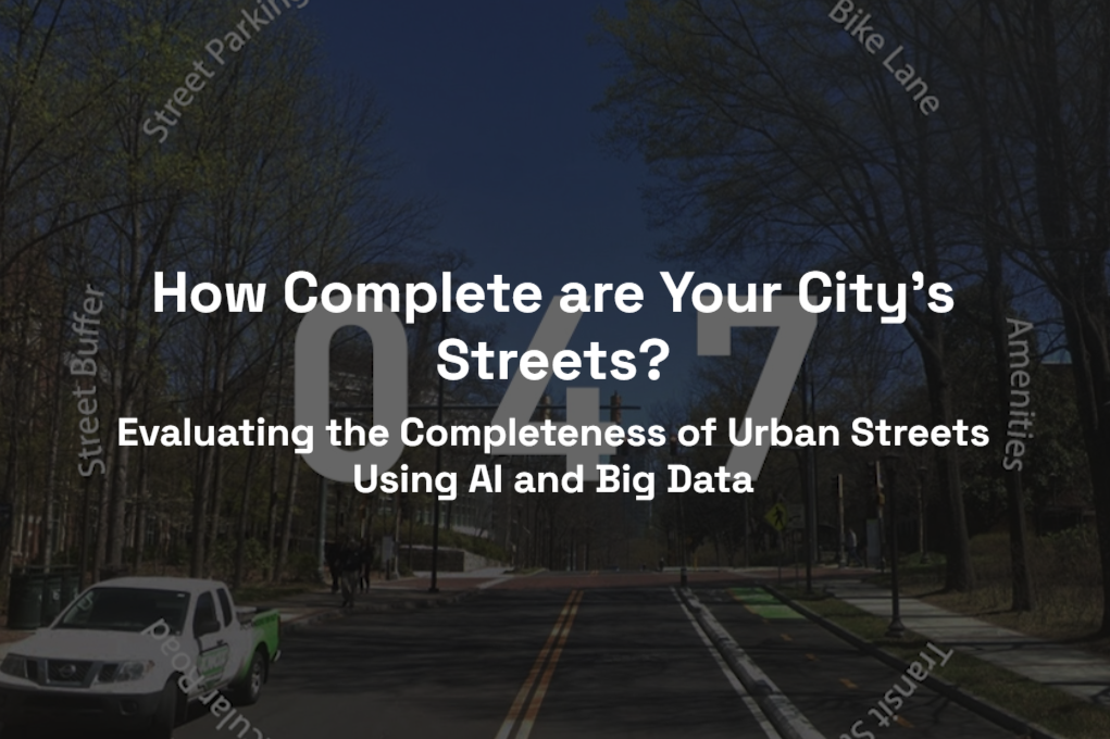
Moving from the 15-Minute City to the Harmonious City
Buildings, lights, streets, and sidewalks. The built environment is the designed spaces that we live in, work from, and travel through. Seung Jae Lieu’s research at Georgia Tech focuses on the built environment, and specifically, where it is possible to walk from one place to another, known as walkability. “My research interests focus on mode choice and the reasons why people choose to use a car or walk to take trips,” said Lieu.
Lieu’s research on the built environment meets at the intersection of the efficiency of engineering and the outdoor aesthetics of city planning, guided by his Master of Science in Civil Engineering and a Master of City and Regional Planning with a specialization in transportation from Georgia Tech. Lieu has a Bachelor of Science in Urban Engineering from Hanyang University in Seoul.
“I was shocked when I moved to Atlanta. There were not that many people walking on the streets’ sidewalks,” said Lieu.
Reflecting on this observation and the data, Lieu developed the “Harmony of Amenities” metric to explore the reasons why people choose to either walk or drive, even when an area has nearby amenities.
As a PhD student at Georgia Tech with the Center for Urban Resilience and Analytics (CURA) and the School of City & Regional Planning, working with advisors Dr. Gulsah Akar and Dr. Subhrajit Guhathakurta, Lieu, is trying to understand both why people make certain choices about what type (also called “mode” choice) of transportation options to use and how streets in urban environments can be more walkable, complete, useful, equitable, and overall harmonious.
Making Walkability à La Mode
The concept of the 15-minute city, which has essential amenities and services within a 15-minute walk or bike ride from residents' homes, was formalized by Carlos Moreno, a scientist and advocate for sustainable cities, at the Paris United Nations Climate Change Conference (COP21) in 2015. The focus of the 15-minute city is on the density of essential amenities, such as grocery stores, pharmacies, schools, and parks.
“But it’s not true that just because you’re close to somewhere, you will walk there,” said Lieu.
When discussing the challenges to the 15-minute city and why people may still use a car even when essential services are located within a 15-minute walk, Lieu described how there are places where the built environment, which includes the neighborhood- and street-level environment, is not safe, comfortable, or connected enough to allow for walking to essential services.
For example, compare the experiences of walking down a shaded, smaller road on a sidewalk with houses, other buildings, and green spaces to that of walking along the side of a multi-lane road with cars rushing by while you are on a small sidewalk, with no shade from trees, and a chain-link fence next to you.
Moving beyond the 15-minute city and time or distance alone, Lieu’s research explores the other dimensions that influence people’s decisions to take trips by walking or biking in place of using a car, such as individual sociodemographic, spatial configuration of amenities, and intended trip utility and purpose.
Moreno’s recent work has also shifted focus from the concept of the 15-minute city to the 30-minute region, with the goal of promoting more flexibility and options for non-car mode choices, especially in areas where things are spread far apart, such as in Atlanta.
A Complete Picture of Walkable Streets
When Lieu assesses walkability, he focuses on the street-level perspective and experience, including perceived comfort and safety. Street-level walkability shapes our immediate walking experience, while neighborhood-level walkability focuses on the overall connectivity between areas and density.
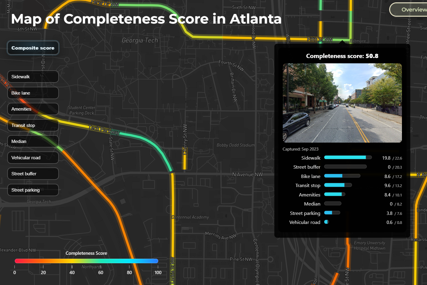
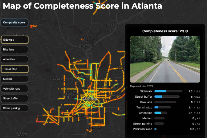
In Lieu’s street completeness work, various large datasets were collected, processed, and scored for sidewalks and bike lanes in an efficient and automated way using artificial intelligence (AI). The final scoring includes elements such as sidewalks, street buffers, bike lanes, transit stops, medians, amenities, street parking, and vehicular roads, and has a street view image of the area to show what it looks like in person.
In the interactive map, you can zoom in and take a close look at Tech Square at 5th Street NW and Spring Street NW. The calculated Completeness Score is 55.3 out of 100.
The Tech Square area in Midtown has high individual scores for sidewalks, bike lanes, street parking, and amenities. On the other hand, there are lower scores for street buffers, medians, and vehicular roads, which may indicate streets that lack completeness in ensuring a pleasant and safe pedestrian experience.
In the Complete Streets mapping tool, individual datasets, such as sidewalks and bike lanes, can be viewed individually, providing a new way to see and explore the completeness of Atlanta’s streets.
“As I developed a tool for street completeness, I realized that other things were going on, such as those related to the location of and types of amenities.”
Where Trip Form and Function Are Harmonious
Just as music can be harmonious, so can be how we travel to and complete tasks in a city. “Urban agglomeration has to do with how amenities and things are related to one another,” said Lieu, “Having two options is better than one, so you can do more in one area if you go there and conduct multiple trips in one time.”
This ability to visit multiple related places on trips led Lieu to develop a novel Harmony Index. Two types of harmonious relationships of amenities are competitive and complementary. For the competitive amenities, this can look like a location with multiple clothing stores located together so there are more options for someone looking for a new piece of clothing. And for a complementary example, this looks like a pharmacy being located near a hospital.
Lieu’s Harmony Index research used non-work trip data from high-accessibility neighborhoods in Chicago to determine where amenities are located (and what they are near), the features of the built environment, the characteristics of the trip takers, and the characteristics of the non-work trips.
Greater sidewalk coverage, access to parks, and visually compact streetscapes were found to promote localized walking behavior. Individuals who are older and who have been living in their homes for a longer period of time were also taking increased walking trips.
A higher Harmony score also reduced the likelihood of people choosing to drive beyond the 15-minute walking area.
Lieu’s Harmony analysis from Chicago, which is currently under review for publication, also found that trips made for frequent purposes tended to remain local and be completed on foot.
Enjoying the Journey at the Intersection of Efficiency and Aesthetics
Atlanta is known as a city planned around long-distance travel in single-occupancy vehicles and large, multilane highways. But there are harmonious havens within the city. For example, neighborhoods such as Sweet Auburn, Midtown Atlanta, and Inman Park have higher walk, transit, and bike scores than others in the city.
Tech Square, located in the heart of Atlanta and Midtown, offers many opportunities for harmonious car-free trips, both complementary, such as visiting the bookstore and going to one of the many coffee shops, and competitive with an abundance of options for dining.
More than just a mode of moving around, our choices, such as walking, rolling, or driving, of transportation mode also impact our health in various ways, as Laurel Bristow, MSc, shared in the “Transportation” episode of Health Wanted, a podcast produced by WABE and Emory Rollins School of Public Health.
Reframing Atlanta as a car-centric city to one designed for people and their experiences at the street level takes collaboration and community. Local organizations such as Propel ATL seek to transform Atlanta’s streets into safe, inclusive, and thriving spaces for people to ride, walk, and roll.
Lieu’s perspective as both a civil engineer and city planner brings together the efficiency required to make cities work for people every day and the empathy for design and human experience that makes the trips we take in cities more enjoyable and harmonious.
Whether it’s a 15-minute city or a 30-minute region, a harmonious city is essential. It’s the experience of enjoying the act of moving between places. When you have a chance to notice the details of the city, the buildings, the plants, and the people, it’s not only reaching your intended destination that matters.